





Description
Data acquisition can also be done automatically via an electronic control unit, and the stratigraphic columns’ export is compatible with other GeoStru applications.
The stratigraphic interpretation can be carried out at the user’s choice, automatically or customized, based on the user’s experience.
The layers can also be inserted with a simple mouse click, and their graphics can be chosen from a lateral database that the user can customize by adding their own bitmaps to existing ones.
The application allows the insertion of the water table as well as the possible verification of soil liquefaction and the calculation of parameters of shallow and deep foundations (bearing capacity).
NEW VERSION IMPLEMENTATIONS
Processing of the characteristic geotechnical parameters with a double system:
- On instrumental readings with normal statistical distribution;
- On geotechnical parameters using the new CVSoil software.
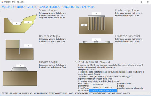
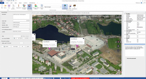
Display of the tests performed on a geographical map.
READINGS FROM THE FIELD SHEET PHOTO (ARTIFICIAL INTELLIGENCE)
- For mechanical cone tests (CPT): the LP and LL readings handwritten on the field sheet are read from a photo or scan of the sheet with GeoStru’s artificial intelligence service, without retyping them;
- Automatic reading of depths, readings, date, client, site and notes; several blocks of columns or several tests on the same sheet;
- Readings checked next to the photo (zoom and pan on the image): uncertain digits highlighted, checks on depths, missing readings and anomalous values, sheet notes and service warnings;
- Choice or creation of a mechanical cone with the same step as the sheet and adjustment of the test depth; cone and sleeve resistance computed at once (manual).
SEISMIC PIEZOCONE (SCPTU)
- Direct import of the Pagani acquisition unit records (left, right and vertical shots): automatic picking of S and P wave arrival times, check and one-click correction on the seismograms, stacking of several shots and signal-to-noise ratio at each depth;
- Direct method for the single-receiver piezocone: times corrected to the vertical on the travel-time curve, seismic layers with constant velocity (found automatically or set by the user) with least-squares line and R²; the pseudo-interval method is still available;
- Vs,eq and ground type according to NTC 2018, G0, Poisson’s ratio and E0 with P waves;
- In the report: S-wave seismograms with the left and right shots in two colours and the picked arrival times, P-wave seismograms, travel-time curves and velocity profile;
- One-page CPTU summary chart: qt, Rf, u2 with the hydrostatic line, Isbt index and SBT classes (Robertson 2010) and Vs profile; piezocone readings can also be imported from the Pagani unit Excel sheet (manual).
INSTRUMENTS
A database of the more common instruments in use is included:
DEEP DRILL, CPT SUNDA DOLMEN ELECTRONIC, GOUDA, PAGANI, Dynastar Tecnotest, WISSA, V.D. BERG (CPT HYSON 200 kn VAN DEN BERG, CPT HYSON 100 kN VAN DEN BERG, CPT HYSON 100 kN VAN DEN BERG, CPT MINI CRAWLER 100 kN VAN DEN BERG, CPT MIDI CRAWLER VAN DEN BERG), FUGRO F5CW/V, TECNO PENTA , Piezocones, Seismic module for S-CPTu tests.
Nevertheless, new instruments can be added and existing ones can be modified or deleted.
TESTS MANAGEMENT
Static Probing allows simple and immediate management of the tests carried out on site: it is possible to insert new tests at any point, assigning the test date, the X and Y position, the Z and the investigated depth, and the water table depth. For each site, it is possible to archive an indefinite number of tests and, for each test, perform the processing with the different correlations proposed. Each test will be easily identifiable on the screen thanks to the legend and the display of the tip and side resistance charts.
DATA INPUT AND LAYER MANAGEMENT
Diagrams of tip and side resistance develop progressively in response to user entry of tip and side resistance readings. Data input may also occur from the electronic data collection device on the instrument.
STRATIGRAPHY MANAGEMENT (Classification of Soils)
Stratigraphy can be produced automatically according to the lithologic interpretations of classical authors:
- Begemann (1965);
- Schmertmann (1969-1978);
- Searle (1979);
- Douglas & Olsen (1981);
- Robertson (1986,1990) (A, B, SBT).
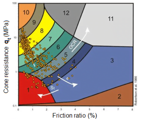
According to more recent authoritative ones in the field of research, or according to personal criteria acquired by the user as the fruit of experience.
EXPORT RESULTS
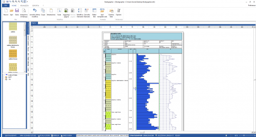
The results of the processing are exported in tabular and graphic form. For each test, tables are created in which the results of the elaborations chosen by the user are reported, preceded by the identification data of the test (order number, date, etc.) and by the characteristics of the instrument used, as well as the data relating to the construction site (project title, location, technician, etc.). Tables can be associated with charts. For graphic completeness, it will be possible to build the stratigraphic column corresponding to each test.
The following geotechnical values are calculated:
- The angle of friction;
- Volume weight;
- Total and effective lithostatic load on the average layer level;
- Relative density Dr;
- Compaction grade;
- Average Nspt value;
- Shear stress-strain modulus;
- Undrained cohesion;
- Vertical permeability;
- Lateral pressure – Ko Coeff.;
- OCR Over consolidation Ratio;
- Compression index Cc;
- Coefficient of consolidation Cv;
- Compressibility factor on the load graph Cm;
- Average Compressibility factor on the load graph Crm;
- Confined consolidation (edometric) modulus compressibility;
- Young’s modulus (E25 – E50);
- Undrained Stress-strain modulus Eu for cohesive soils;
- Cohesion and drained friction for cohesive terrains (Erminier’s method);
- Liquefaction.
Implemented import of .xml data files for new static penetration test dataloggers (CPTe/CPTU), e.g. CPTU-ACQ for TGAS – Pagani G.E. acquisition system. Added a new instrument list; please note that in Static Probing users can add and customize any testing instrument.




Dario Battistella (verified owner) –
Buon programma, ci sono dei piccoli problemi di visualizzazioni con alcune scale e qualcosa da migliorare nella valutazione dei paramtri geotecnici
filippo catanzariti (verified owner) –
Buongiorno mi invii su info@geostru.eu le osservazioni