


Description
Geotechnical characteristic parameters: The concept of limit state was developed in parallel with the concept of the characteristic value.
Eurocode 7, concerning the geotechnical design, introduces the characteristic values of geotechnical parameters for the first time.
The characteristic value understood as a precautionary estimate of the parameter that influences the onset of the limit state into consideration must be used in any geotechnical verification.
The works must be verified for the ultimate limit states that may occur as a consequence of different combinations of actions and for the serviceability limit state, defined about the expected benefits.
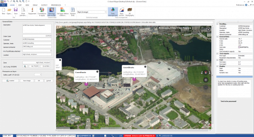
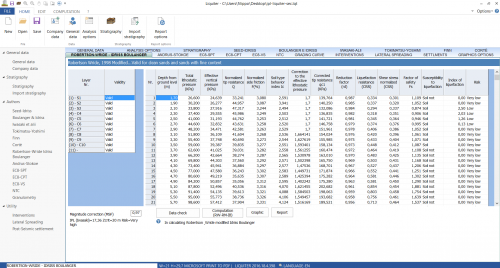
CVSOIL “Geotechnical characteristic parameters“: The software calculates the expected values of the soil by analyzing the parameters obtained from the surveys. The geotechnical parameters are treated as random variables, and the set of values of the parameters is a statistical population; With CVSoil, it is possible to import data from multiple surveys within the same area. Data entry is simple and intuitive; The area of investigation can be displayed on Google Maps. The parameters that can be statistically analyzed are Angle of internal friction, Drained cohesion, Undrained cohesion, Relative density, Consistency index, Oedometric modulus of compressibility, Shear modulus, Young’s modulus, Nspt, Natural unit weight, Saturated unit weight, Pocket penetrometer, Poisson’s ratio, Uniaxial compressive strength, Static cone resistance, Natural moisture, Shear waves velocity, Custom parameters.
NORMATIVE REFERENCES
Eurocode 7
STATISTICAL APPROACH
Normal Distribution Lognormal Distribution Student’s Distribution Bayes’ theorem a small number of samples Calculating geotechnical parameters according to compensated and uncompensated resistance criterion.
SHARING SURVEYS ON THE WEB
CVSoil is not a simple software for determining characteristic parameters; its architecture has been designed for the general organization of geotechnical tests. The users can choose to share their surveys on the web, and the publication will be done together with the details of the license owner so that the software will become a great advertising tool for the license owner. It is also possible to search for shared surveys with search filters based on area and distance from the place of investigation.
DATA EXCHANGE WITH OTHER GEOSTRU APPLICATIONS
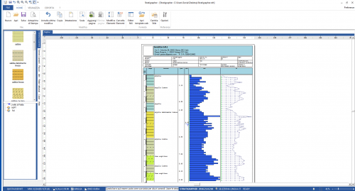
CVsoil allows you to import data from Static and Dynamic Probing automatically. The processed data can be automatically sent to all GeoStru software. Output CVSoil creates a report that can be exported in the following formats: RTF, DOC, DOCX, PDF, HTM, JPEG etc.


Reviews
There are no reviews yet.