


Description
Software for the interpretation of dynamic penetration tests.
Processing the tests for the computation of bearing capacity of shallow foundations using numerous methods, for the calculation of various geometries (Strip Footings, Mat foundations, Spread footings, etc.) and related settlements, the verification of driven piles and the definition of the liquefaction potential of soils subject to seismic forces. The graphics of the stratigraphic columns can be exported in Slope, LoadCap, and MP (Piles and Micropiles); in particular, for the last two applications, are also exported the geotechnical parameters as results of the processing.
Data processing is instantaneous, deriving the values of NDP & Rd and immediately generating a graphic display. In addition, the software proposes discrete layer boundaries and enables bitmaps or colors to be assigned for lithologic coding.
EQUIPMENT
The software has a database of commonly used test equipment:
-
- Borro;
- DIN 4;
- DPM (DL030 10) (Medium);
- DPM (DL030 16) (Medium);
- DPA;
- DPL (Light);
- DPSH (Dynamic Probing Super Heavy);
- SCPT (Standard Cone Penetration Test);
- SPT (Standard Penetration Test);
- DPSH TG 63-X PAGANI;
- SCPT TG 63-X PAGANI;
- DPM (DL 030 SUNDA);
- RAYMOND;
- PENNY 30;
- Geo Deep Drill (DPH50, DPSH63-73), GeoDeepDrill DM30;
- Nordmeyer (LMSR-X model);
- STITZ gmbh Germany: Pneumatic, lightweight penetrometer DPL; Pneumatic, lightweight penetrometer E-DPL. Pneumatic operated heavyweight penetrometer DPH; Pneumatic operated heavyweight penetrometer E-DPH;
- GEOPC Comacchio SPT (Standard Penetration Test), DPH (Dynamic Heavy Probes), e DPSH-A (Dynamic Super Heavy Probes).
User equipment: Any type of custom equipment can be added *
The correlation coefficient is calculated automatically for each new piece of equipment added.
For the calculation of N60, N1,60 are required: CE (energy correction factor ), Cn (overburden correction factor), Cr (rod length correction factor which depends on the total length of the drill rod), Cb (bore-hole diameter correction factor and its is set according to the selected diameter from the drop-down list), Cs (liner correction factor).
EXPORT EQUIPEMENT ARCHIVE
The equipment list can be exported in XML or txt format and imported into installation locations other than the local PC.
DATA INPUT AND LAYER MANAGEMENT
Dynamic Probing features clear and straightforward processing of readings obtained on site.
DATA ENTRY
As the user enters the number of blows for each penetration step, the sampler bit coefficient, reduced, and non-reduced, as well as dynamic resistance on the layer, are calculated; also, a bar diagram for the number of blows and a graphic representation of the progress of dynamic resistance is shown.
LAYER MANAGEMENT
Even more simple is the definition of the layers: the user can define the stratigraphy (layer depth and lithological characterization) numerically or graphically as the software allows the interactivity between the dialogue boxes.
READINGS PROCESSING
Dynamic Probing features clear and straightforward processing of readings obtained on-site.
New readings may be inserted at any point, assigning the cartesian position coordinates (X and Y), the initial depth (Z), the final depth, the groundwater table depth, if any, and the date. An indefinite number of readings may be recorded for each site, and the correlations suggested developed. Each reading is easily identified visually thanks to the legend and displays graphics of dynamic resistance and the number of blows.
CORRELATIONS
The user may indicate the geotechnical parameters of particular significance for terrain characterization. The lithologic cases that originate the numerous correlations accompanying the program enable the user to characterize various terrains. The user is further provided with tools to select for use those correlations judged to most nearly reflect the lithotypes actually encountered. The parameters that are the outcome of the computation are:
Cohesive terrains
-
- Undrained cohesion (Terzaghi-Peck, SUNDA (1983)-Benassi Vannelli, Sanglerat, TERZAGHI & PECK (1948), U.S.D.M.S.M., Schmertmann (1975), Fletcher (1965), Houston (1960), Shioi – Fukui (1982), Begemann, De Beer, Robertson (1983));
- Edometric modulus (Stroud e Butler (1975), Vesic (1970), Trofimenkov (1974), Mitchell e Gardner, Buisman-Sanglerat);
- Young’s modulus (Schultze-Menzenbach, D’Appollonia ed al1983);
- Unit volume weight (Meyerhof ed al);
- The new empirical formula based on a dynamic probing test in fine cohesive soil (M. Khodaparast1,*, A.M. Rajabi2, M. Mohammadi3): Cu, undrained shear strength, MR is the resilient modulus, CBR, California bearing ratio for Soft Clay, Hard Clay, Clay, Fine soil;
- Others…
Cohesionless soils
-
- Relative density (Gibbs & Holtz (1957), Meyerhof (1957), Skempton (1986), Schultze & Menzenbach (1961));
- Friction angle (Peck-Hanson-Thornburn-Meyerhof (1956), Meyerhof (1956), Sowers (1961), Malcev (1964), Meyerhof (1965), Schmertmann (1977), Mitchell & Katti (1981), Shioi-Fukuni (1982), Japanese National Railway, De Mello, Owasaki & Iwasaki);
- Oedometric modulus (Buisman-Sanglerat, Begemann (1974), Farrent (1963), Menzenbach e Malcev);
- Young’s modulus (Terzaghi, Schmertmann (1978), Schultze-Menzenbach, D’Appollonia ed al (1970), Bowles (1982));
- Poisson’s modulus (A.G.I.);
- Shear deformation modulus (Ohsaki & Iwasaki, Robertson and Campanella (1983));
- Weight by unit volume (Meyerhof ed al);
- Classification (A.G.I.);
- Shear wave velocity;
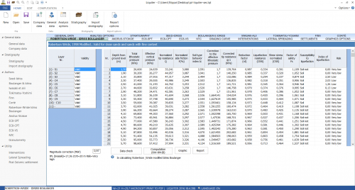
- Liquefactive potential (Seed (1979));
- Ko modulus (Navfac (1971-1982));
- Others…
New correlations for: N60, N160, Modulus oedometric stress-dipendent in according: EC7, DIN 4094-3
COMPUTATION
For each sampling, based on the user-selected soil type (Cohesive or Non-cohesive), computation is performed layer by layer. Thereafter for each layer, the parameters of all the proposed correlation parameters are calculated, particularly highlighting the ones favoured by the user.
The number of blows, depth, the correlation applied, and the calculated geotechnical parameter value may be exported for each layer.
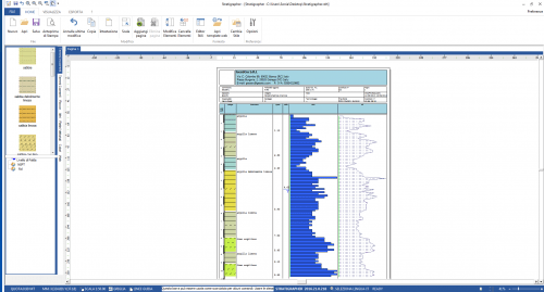
EXPORT OF RESULTS
The results are exported in tabular and graphical format. For each test is created a table where are inserted the results of the tests chosen previously by the user preceded by the identification data of the test (order number, date, etc.) and by the characteristics of the equipment used, as well as the data related to the site (project title, location, engineer, etc.). The tables can be associated with graphs of the number of blows and the dynamic resistance. It is also possible to build the stratigraphic column corresponding to each test.
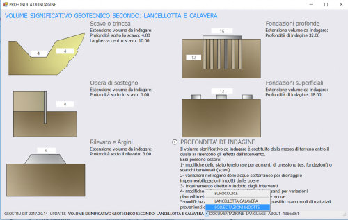
BEARING CAPACITY AND LIQUEFACTION
Dynamic Probing calculates the bearing capacity and settlement of surface foundations utilizing several methods and additionally calculates the liquefaction potential of non-coherent layers.
SECTIONS IN DYNAMIC PROBING
Dynamic Probing enables the automatic generation of sections from test data using the ‘Sections’ module. A command enables the selection of those tests on which the generation of the sections is based and opens the new application. (The same procedure can be used from the GeoStru program ‘Static Probing’, the counterpart of Dynamic Probing for Static penetrometers).
The Sections module is actually a stand-alone section editor within, which sections can be created. Further, it enables an import of stratigraphic columns originating from the GeoStru programs ‘Stratigrapher’.
‘Sections’ is interfaced with GeoStru program Slope, so the sections generated can be read as input by this program to analyse their stability.
3D SECTIONS
For a minimum of three tests, Dynamic Probing can perform the three-dimensional reconstruction of the stratigraphy.


cesare bisiccia (verified owner) –
Software rapido ed efficace. Le correlazioni presenti vanno studiate attentamente perché valide solo per determinate tipologie di terreni; andrebbero inoltre aggiornate, ormai ne esistono di migliori. Nel complesso il miglio software che abbia mia visto per questo genere di elaborazione.
Maxim Dinev (verified owner) –
Very usefull software.
Domen (verified owner) –
Useful program
gegillett (verified owner) –
We have been using this program for about five years and have been very happy with it. We often use the various correlations that come built-in and export to another software for reporting purposes. We also noted that the depths of boreholes seem to be limited to about 20m which can be inconvenient if you usually have tests that exceed this depth. Generally, it is very useful software and we look forward to future upgrades.
filippo catanzariti (verified owner) –
Thank you for the review. You should have no limits on depth. Send me more information on this to my email info@geostru.eu
Pietro Balducci (verified owner) –
Buon software. Da migliorare il report delle indagini.
Enzo Massaro (verified owner) –
Purtroppo con l’ultima versione, come già vi ho rappresentato, sto incontrando diversi problemi, tra questi quelli di seguito elencati:
– nella sintesi parametri geotecnici, quando attribuisco ai materiali un comportamento granulare/coesivo, l’angolo di attrito lo da pari a zero;
– quando vario un parametro e procedo alla rielaborazione le tabelle conseguenti compaiono vuote e sono costretto a chiudere il programma per poi riaprirlo e riaprire il file;
– non riesco, probabilmente non ho trovato la strada giusta, a stabilire la dimensione delle tabelle da assumere poi come impostazione di default, stesso discorso per il testo di output (carattere e dimensione).
Ho provveduto, come da vostro consiglio, a disinstallare ed installare nuovamente il software ma i problemi su citati permangono.
filippo catanzariti –
Egr. Enzo non abbiamo rilevato i problemi segnalati ci contatti su (info@geostru.eu) per stabilire un appuntamento per una assistenza remota. Per segnalare questioni tecniche usi support.geostru.eu
Claudio Di Marzio (verified owner) –
Buongiorno, il programma ha buone funzionalità. Ci sono aspetti che migliorerei, ma sarebbe da studiarci un po’ sopra. Una cosa che invece prorio non capisco è perchè, nel passaggio automatico all’elaborazione a passo strumentale, è possibile ereditare la stratigrafia, ma non l’a selezione degli autori già scelti. Non vorrei che il programma già prevedesse questa funzionalità di cui potrei non essermi accorto, ma se fosse così come penso, reinserire gli stessi autori, oltre che una inutile perdita di tempo, è anche l’occasione per incorrere a gravi errori.
Ringrazio della gentile risposta!!!
Cordiali saluti,
Claudio
filippo catanzariti –
Dear Sirs,
I have some additional questions according to my use of Your excellent program:
I have SPT measurements from some boreholes. How can I make profile (like DPL measurements) with just four data, which are not equally spaced.
I would like to compare my previous calculations od SPT into N1(60): how can I calculate N1(60) with this results on Dy.prob.?
We classificate soil as GM, GC. What calculations shall we use: for cohesionless or cohesive soil.
Survey Engineer Intertech –
Dear Sirs,
We have received an introduce from Pagani that your company supply software interpretation. We are interest your software for processing Pagani TG30-20 SE penetrometer. Please suggestion with quotation and catalog by return.
We look forward to hearing from you.
Best regards,
Survey Engineer Intertech Co. Ltd
Thailand
tibor –
Dear Sir/Madam,
I am user of DYNAMIC PROBING for about ten years and I’m very satisfied (if I were not, I didn’t used it).
Yesterday WINDOWS 10 made a profound update (it worked more then 1 our) and since then the program does not work properly.
Kristopher Murphy (verified owner) –
From the first release, thanks to the continuous updating of the software by GeoStru staff, Dynamic Is the most reliable and powerful of the products on the market.
In addition, the possibility of having a direct relationship communication between the global user community and GEOSTRU, makes the product even more efficient.