


Description
6
Software for the interpretation of seismic refraction tests was implemented to ensure the quality standards of GeoStru, including ease of use, full control over operational phases, the preparation of the automatic report printing and the ability to export all the charts and graphs.
The definition of the array geometry is extremely flexible and does not impose constraints on the number of shots to be used in the analysis.
The software can guide the user through the analysis phases offering full control of the operative process.
The program has implemented an efficient locating system that allows editing the aerial photo of the research area.
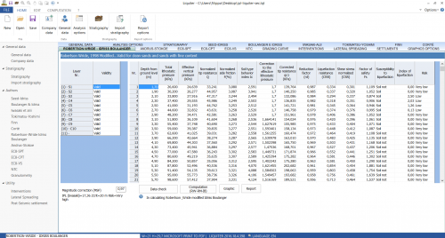
Field data is extracted directly from the files generated by loggers (in formats like SEG2, SEGY, SU, etc.) and plotted to give the user the identification of the first arrivals, which can also be entered manually or by copy/paste.
As a function of identifying the first arrivals, the software can operate the regression analysis and identify the time travel curve.
Through this analysis phase, arrival times are assigned to the correct refractors.
After building the time travel curve and identifying the propagation velocity of the seismic signal in the different soil layers, the Generalized Reciprocal Method is applied.
This method is based on the research, in the time-distance diagram, of an optimal distance between geophones XY, in such a way that the seismic rays coming from opposing shot points, positioned symmetrically at the ends of the array, arrive from the same point of the refractor on the geophones placed in X and Y.
In addition to performing an automatic search of the optimal XY, EasyRefract provides, for the eligible values XY, the diagram of the velocity function with the standard deviation for each associated regression and the diagram of the time-depth function with the roughness value.
OTHER CHARACTERISTICS
-
- Finding the area of intervention by the satellite map;
- No constraint on the number of geophones or sources;
- Import seismic data from files like SEG2, SEGY, SU, etc.;
- Standard Guide for Using the Seismic Refraction Method for Subsurface Investigation;
- Apply filter to traces;
- Selection of the display amplification factor to be applied to different traces in files;
- Definition of the first arrivals on the seismogram with the possibility to choose the zoom or to display on a separate window the segment of signal useful in search of first arrivals;
- Manual definition of the first arrivals through direct entry or the use of copy-and-paste commands;
- Customer definition of the time travel curves;
- Automatic detection of slope change points;
- Choice of the optimal XY on the diagram of the velocity function or on the diagram of the time-depth function;
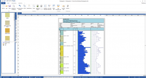
- Customizing the stratigraphy with the use of textures;
- Exporting the calculation report in formats like doc, docx, pdf, etc.;
- Export of all diagrams on files;
- Export of stratigraphy in dxf.


Lucia Santopietro (verified owner) –
ho testato differenti software della GEOSTRU, generalmente i software sono abbastanza intuitivi e facili da utilizzare.
Manuali e videotutorial da integrare.Nel complesso buon prodotto, non metto 5 stelle perchè si può sempre migliorare
Emilio (verified owner) –
ottimo software per la rifrazione, facile e molto pratico da usare rispetto ai più blasonati sw
Mario Cimieri (verified owner) –
Semplice ed intuitivo come tutti i programmi della Geostru.. chiaramente bisogna conoscere bene la materia e soprattutto la tecnica della rifrazione. Io comunque mi trovo molto bene.
Lucio (verified owner) –
Buono, a volte ho avuto problemi nell’interpretazione anche se come tutti i programmi geostru è semplice ed intuitivo
Marcello Brancucci (verified owner) –
Buon prodotto,
con le ultime versioni non riesco più a spostare la legenda che è bloccata a destra della sezione sismica.
Solita carenza cronica nei contenuti del manuale.
Per il resto fa il suo dovere
Gianluca Tomassoni (verified owner) –
facile e intuitivo, software valido
Giorgio Ligorini (verified owner) –
Ottimo prodotto,
testato con altri software molto più costosi è risultato sempre affidabile ed intuitivo con risultati verificati successivamente durante le opere di scavo in cantiere. Ottimo per la costruzione delle domocrone, per l’interpretazione dell’assetto stratigrafico e per l’esportazione dxf.
Migliorerei la veste grafica e soprattutto Il manuale che invece ho trovato un po’ carente.
Robert Navarro Mori (verified owner) –
Muy buen producto
Eduardo Carvacho (verified owner) –
Amigable para usar,
Paolino Vercillo (verified owner) –
E’ il software ideale per chi pratica la sismica a rifrazione, la sua completezza deriva dalla versatilità del prodotto.
E’ di facile utilizzo anche per coloro che si avvicinano per la prima volta a questo tipo di prospezione sismica.
E’ necessario che il manuale venga integrato esplicitando con maggior puntualità l’aspetto fisico di alcuni argomenti come “Dromocrone traslate” e la “Selezione Automatica” degli strati.
Comunque complimenti per il software.
Marcello Brancucci –
Buongiorno,
rilevo qualche carenza del manuale di istruzione relativamente alla procedura operativa nel piking e della gestione dei modi.
Anche il video sul canale you tube è poco chiaro in merito.
Come ben sapete io utilizzo molti dei vostri software d atempo e questa dei manuali è una carenza di sempre sulla quale una azienda seria come la vostra dovrebbe ora investire in maniera decisa ripubblicandoli tutti un pò alla volta.
Cordiali saluti.
RICCARDO (verified owner) –
SOFTWARE SEMPLICE, INTUITIVO, MOLTO PRATICO E, SOPRATTUTTO, AFFIDABILE E RISOLUTIVO.
PERSONALMENTE L’HO CONFRONTATO CON PROGRAMMI ANALOGHI, PIU’ MACCHINOSI, CHE DOPO VARI RISCONTRI HO PROGRESSIVAMENTE ABBANDONATO.
VERAMENTE INTERESSANTE.