


Description
SOFTWARE FOR INTERPRETING AND ARCHIVING SEISMIC DATA USING THE MASW METHOD
(Multi-Channel Analysis of Surface Waves)
The software allows the inversion using more modes.
During the spectral processing phase, the user can view the dispersion of a customizable synthetic model, and the results are plotted directly on the velocity-frequency spectrum.
The generation of the velocity-frequency spectrum has been improved to allow more effective identification of modes.
The user can select the points on which the inversion is performed directly on the velocity-frequency spectrum and assign to each point the mode to which it refers.
IMPORTING INPUT DATA
Data can be imported from files in SEG2, SEGY and SU standard format and text files.
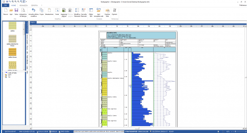
After importing data, the design of the geometrical arrangement of springs and receivers will be processed.
The design is a complete report which shows the altitude of the geophone’s positions and the depth scales.
In addition to the geometric position are displayed field seismograms.
At this stage, the user can make operations on the signals deciding to exclude part of seismograms, or move or add virtual arrays.
SIGNAL ANALYSIS
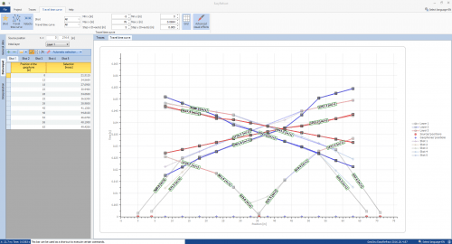
The analysis of Rayleigh waves using the MASW technique is performed with the spectral investigation of the signal, performing a double Fourier transform in the time and space domain.
The transformed domain (f-k) is represented in both 2D and 3D and allows highlighting of the signal produced by Rayleigh waves from other types of signals.
In the transformed domain, in fact, is well detectable the dependence of wave velocity on the frequency and the dispersion curve is easily traceable considering, for each frequency, the maximum amplitude of the spectrum.
The program extracts the experimental dispersion curve automatically, and the user can approximate it to a polynomial function that can be adjusted by excluding the insignificant points.
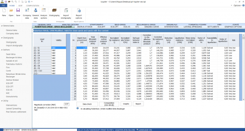
THEORETICAL INVERSION CURVE
After assigning an initial geotechnical model characterized by values such as the number and thickness of the layers, weight per unit volume, Poisson’s ratio, etc., the theoretical inversion curve is compared with the experimental one.
The variability of the parameters continues until the best superposition of the theoretical curve is obtained with the experimental inversion curve, in the range established during the picking phase.
The process of matching was conducted with advanced statistical numerical methods.
A series of additional features allow direct control of the delicate inversion process: it is possible to determine the range of variability of the speed for each layer, impose known speed on the single layer, assign special conditions such as speed increasing with depth, etc.
DISPLAYING MODES
For each processing, it is possible to view, in addition to the fundamental mode, which is based on the process of curve matching, even the higher modes.
Geotechnical parameters
Easy Mass allows determining, in addition to the speed profile, the VS30, the soil class and some geotechnical parameters such as Young’s Modulus, Shear Modulus, Edometric Modulus, Compressibility Modulus, tip resistance of the static penetrometer, Nspt correlation with a dynamic penetrometer.
EXPORT
It is offered a detailed output report, including numerical computation and graphics. The graphics can be exported in common formats, such as.DXF, .BMP, .JPG.
EXCHANGING DATA BETWEEN GEOSTRU APPLICATIONS
The seismic test can be exported to other GeoStru software such as Slope, Loadcap, Mp and Stratigrapher to prepare the stratigraphy.


MAURO (verified owner) –
PRODOTTO SEMPLICE ED IMMEDIATO DA USARE
Antonella Calice x Piano Terra (Federico VIA) –
sono ottimi prodotti tutti quanti ma si potrebbe fare l’aggiornamento tramite solo il codice rinnovato e non ogni volta disattivare, reinstallare tutto e attivare la licenza…. si dovrebbe snellire la procedura anche perché se uno ( come noi) aggiorniamo 16 applicazione ogni anno comincia a essere deprimente ogni volta iniziare da capo.
grazie mille
Mario Trujillo Calderon (verified owner) –
Es un excelente producto para la interpretación de ensayos de refracción sísmica, conozco bastantes software de este tipo, sin embargo este es el mejor por los resultados obtenidos y la presentación del informe, adicionalmente el soporte técnico de geostru es muy buenos, son muy rápidos en contestar las dudas y muy amables, sin duda alguna es una excelente adquisición